

DJI Matrice 400
High-Performance Drone Platform for Inspection, Surveying & Industrial Operations
The DJI Matrice 400 represents the latest generation of enterprise drone platforms, designed for demanding aerial operations across inspection, surveying, and public safety sectors. With extended flight endurance, high payload capacity, and advanced sensing technologies, the Matrice 400 enables operators to capture critical data safely and efficiently.
Equipped with intelligent obstacle sensing, advanced video transmission, and support for multiple payload configurations including LiDAR, visual, and thermal sensors, the platform is built to handle complex operational environments. From infrastructure inspections and energy asset monitoring to mapping, emergency response, and engineering applications, the Matrice 400 delivers reliable performance for professional drone operations.

Zenmuse
P1

ZenmuseH30T

Zenmuse
L3

Zenmuse S1

Zenmuse
V1
Flexible Payload Integration for Multiple Mission Types
The DJI Matrice 400 is designed to support a wide range of professional payload configurations, allowing operators to adapt the platform to different mission requirements. With a maximum payload capacity of up to 6 kg, the aircraft can carry multiple sensors simultaneously, supporting complex aerial operations across inspection, surveying, and industrial applications.
The Matrice 400 platform supports flexible gimbal configurations and multiple external expansion ports, enabling integration of advanced payloads such as LiDAR scanners, high-resolution cameras, and thermal sensors. This flexibility allows operators to capture multiple data types in a single flight, improving operational efficiency and reducing time spent in the field.

Expanded Payload Compatibility
The DJI Matrice 400 supports a wide range of professional payload options, allowing operators to configure the aircraft for different mission requirements. Compatible payloads include the Zenmuse H30 Series, L2 LiDAR, P1 mapping camera, S1 Spotlight, V1 Speaker, and Manifold 3 onboard computer, as well as selected third-party sensors.
This flexible payload ecosystem allows the Matrice 400 to adapt to applications such as infrastructure inspection, mapping and surveying, public safety operations, and industrial monitoring. By supporting multiple payload integrations, the platform enables operators to expand capabilities and maximise the value of the DJI Enterprise ecosystem.

Zenmuse H30 Series
The Zenmuse H30 Series integrates five major modules,
wide-angle camera, a zoom camera, an infrared thermal camera, a laser range finder, and an NIR auxiliary light. Employing cutting-edge intelligent algorithms, it revolutionizes perception and imaging standards, transcending the limitations of day and night vision.

Zenmuse L3
Zenmuse L3 features a 1535nm long-range LiDAR, dual 100MP RGB mapping cameras, and a high-precision POS system. It can be mounted on Matrice 400 using the Zenmuse L3 single gimbal connector, accelerating geospatial data acquisition.

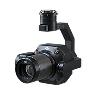
Zenmuse P1
Zenmuse P1 integrates a full-frame sensor with interchangeable fixed-focus lenses on a 3-axis stabilized gimbal. Designed for photogrammetry flight missions, it takes efficiency and accuracy to a whole new level.

Zenmuse V1
Zenmuse V1 is DJI's first loudspeaker designed for multi-payload drone platforms. It boasts high volume and long broadcast distance, and supports multiple broadcast modes, making it ideal for scenarios like public safety, emergency rescue, and more.

Zenmuse S1
Zenmuse S1 is DJI's first spotlight designed for multi-payload drone platforms. Utilizing the LEP technology, it offers high brightness and long illumination distance, and supports multiple lighting modes. This makes it ideal for public safety, emergency rescue, inspection, and other nighttime operations.

Manifold 3
Manifold 3 packs an impressive 100 TOPS of computing power into a compact unit weighing about 120 g. It can be mounted onto Matrice 400 drone platform, optimizing efficiency across various operational missions with its robust processing.
Flight Time
Estimate the Matrice 400’s flight time based on payload configuration.

Extended Flight Endurance & High-Speed Performance
The DJI Matrice 400 is engineered for demanding aerial missions that require long flight durations and reliable performance. The platform offers up to 59 minutes of forward flight time with payload and up to 53 minutes of hover endurance, allowing operators to complete complex missions with fewer battery changes and greater operational efficiency.
With a maximum flight speed of up to 25 m/s, the Matrice 400 can cover large operational areas quickly while maintaining stable flight and advanced obstacle awareness. These capabilities make it well suited for long-duration operations such as infrastructure inspections, large-scale mapping projects, emergency response missions, and industrial monitoring.
Up to 59Mins
Forward Flight Time
Up to 25m/s
Flight Speed
Powerline-Level Obstacle Detection
The DJI Matrice 400 features an advanced multi-sensor obstacle detection system designed for safe operations in complex environments. By combining rotating LiDAR, millimetre-wave radar, and low-light fisheye vision sensors, the aircraft can detect and respond to obstacles with exceptional accuracy.
This system enables the drone to identify thin structures such as power lines and cables, even in low-visibility environments or challenging terrain. The integrated sensing technology also improves operational safety in conditions such as rain, fog, and low light, allowing pilots to maintain situational awareness and avoid obstacles during demanding inspection missions.
Built for Demanding Environments
The DJI Matrice 400 is designed to operate reliably in challenging field conditions. With an IP55 protection rating, the aircraft is built to withstand dust, moisture, and rain, making it suitable for demanding industrial and infrastructure operations.
The platform is also engineered to maintain stable performance across a wide temperature range, operating effectively from -20°C to 50°C (-4°F to 122°F). This allows the Matrice 400 to deliver consistent results in both extreme cold and high-temperature environments, supporting missions such as infrastructure inspection, emergency response, and large-scale mapping.

IP55
IP Rating
-20° to 50° C (-4° to 122° F)
Operating Temperature
Robust Video Transmission
Reliable Long-Range Video Transmission
The DJI Matrice 400 features the advanced O4 Enterprise Enhanced Video Transmission system, delivering stable, high-quality live video feeds over long distances.
With a multi-antenna transmission system and high-gain signal architecture, operators can achieve video transmission ranges of up to 40 km, providing reliable situational awareness during complex missions.
The system also supports sub-2G frequency bands and can be equipped with dual cellular connectivity, allowing the aircraft to automatically switch to the strongest available network. This ensures a stable video link even in environments with signal interference or limited infrastructure.
For operations in difficult terrain or extended distances, the Matrice 400 supports airborne relay functionality.
In this configuration, one aircraft can act as a relay platform, transmitting the signal between the pilot and a second drone operating further away. This significantly increases operational range and improves communication reliability in environments such as:
-
mountainous terrain
-
remote infrastructure corridors
-
large-scale search and rescue operations
This relay capability allows teams to maintain stable video transmission and operational awareness even in areas where direct signal connectivity would normally be limited.
Extended Coverage for Remote Operations

Advanced Fusion Positioning
The DJI Matrice 400 uses an advanced sensor fusion positioning system designed to provide stable and precise flight performance in complex environments.
By combining rotating LiDAR, high-precision mmWave radar, and low-light fisheye vision sensors, the aircraft maintains accurate positioning even when operating close to structures or in environments where GPS signals may be limited.
This multi-sensor approach enables safe flight operations near challenging surfaces such as glass buildings, wind turbine blades, bridges, and large infrastructure assets, giving operators greater confidence during inspection and monitoring missions.
The system also enhances return-to-home reliability by maintaining accurate spatial awareness, allowing the aircraft to safely navigate away from structures and obstacles during automated flight procedures
Full-Color Vision Assist
The DJI Matrice 400 is equipped with four full-color low-light fisheye vision sensors that provide enhanced visual awareness for the pilot during flight operations.
This system delivers Full-Color Vision Assist, enabling operators to maintain better situational awareness even in low-light environments. By providing a clear visual feed of the aircraft’s surroundings, the system helps improve navigation and operational safety during complex missions.
The integrated vision sensors support safer flight operations when working around infrastructure, terrain, or obstacles, giving operators additional visual confidence during inspection, mapping, and public safety missions.
Enhanced Intelligence and Operational Efficiency
Smart Detection
When equipped with advanced payloads such as the Zenmuse H30 Series, the DJI Matrice 400 enables powerful smart detection and tracking capabilities using both visible and thermal imaging sensors.
This intelligent system allows operators to identify and track vehicles, vessels, and individuals during operations such as search and rescue, security monitoring, and infrastructure inspections.
The platform also supports high-resolution grid capture and automated tracking functions, enabling efficient data collection and improved situational awareness during routine missions or emergency deployments.
These capabilities allow organisations to increase operational efficiency while reducing manual workload, making the Matrice 400 a highly effective tool for complex aerial operations.
Smart AR Detection
Power Line AR
For power grid inspections, the DJI Matrice 400 detects overhead wires and displays AR guidance lines on the controller, improving situational awareness and flight safety.
Live Annotations
Operators can mark points directly on the controller screen to determine target locations, measure distances, and calculate areas. Measurement data can also be synchronised with DJI FlightHub 2 to support coordinated team operations.
Map View AR
In urban environments, the controller highlights landmarks, buildings, and major roads in real time, improving navigation and situational awareness for day and night operations.
AR Flight Waypoint
During RTH, obstacle sensing, and FlyTo operations, pilots can preview the drone’s route in real time. The AR aircraft shadow also appears during landing to help confirm the landing position.

Real-Time Terrain Follow
The DJI Matrice 400 supports real-time terrain following in any horizontal direction, allowing the aircraft to maintain a consistent height relative to the ground. This feature can be used during both manual flight and automated mission routes, helping ensure stable and reliable operations over uneven terrain.
For large-scale search and rescue missions, terrain following allows subjects on the ground to remain consistently visible on the controller display, reducing the need for constant zoom adjustments and improving operational efficiency. During mapping missions, it helps maintain a consistent ground sampling distance (GSD), enabling the collection of high-precision mapping data.

Takeoff and Landing on Ships
The DJI Matrice 400 supports reliable takeoff and landing operations from vessels, enabling drone deployment in offshore and maritime environments. This capability allows operators to launch from stationary platforms or safely recover the aircraft on moving vessels.
Using advanced positioning and landing detection systems, the aircraft can recognise landing zones on deck and perform controlled, accurate landings even in dynamic conditions.
This makes the Matrice 400 well suited for operations such as offshore wind turbine inspections, maritime patrol, coastal monitoring, and search and rescue missions.
Intelligent Flight Modes
Cruise
Activate cruise control mode to pilot the drone in a specific direction without constantly pressing the control sticks, making long-distance flights or linear inspections easier.
POI
POI enables continuous observation and 3D modeling of buildings while orbiting a designated area, greatly enhancing the efficiency of fixed-point observation and modeling tasks.
Smart Track
Smart Track allows for precise subject positioning and automatic zoom adjustments, allowing you to switch between subjects easily. It can automatically reacquire a subject even if obscured briefly.
FlyTo
In emergencies or disasters, the drone can automatically adjust its flight path and speed based on the surrounding environment, allowing it to reach a designated location without manual adjustments.
Easier Automated Operations
Power Line Follow With Zenmuse L3/L2
When Matrice 400 is equipped with the L3 (via the Zenmuse L3 single gimbal connector) or L2 LiDAR system, it can perform automated power transmission and distribution line following flights. The onboard rotating LiDAR detects obstacles in real time, allowing the drone to automatically bypass crossing lines.
Slope Route & Geometric Route
Matrice 400 supports the planning and execution of slope and geometric routes via DJI Pilot 2 or DJI FlightHub 2. Whether conducting detailed aerial surveys of building facades, slopes, or other inclined surfaces, or collecting mapping data of individual buildings or structures, Matrice 400 can quickly plan slope or geometric routes to efficiently acquire high-precision data.